| [12:43:51] | <symbioquine[m]> | https://github.com/farmOS/farmOS/pull/864 should be ready for review! |
| [12:44:39] | <symbioquine[m]> | Resulting tags/manifests: https://hub.docker.com/repository/docker/symbioquine/farmos/tags |
| [12:47:26] | <symbioquine[m]> | For those following along at home, �docker run -p 80:80 --rm symbioquine/farmos� works on X86_64 and Arm32v7/Arm64v8 architectures (I plan on deleting Docker hub �symbioquine/farmos� once the PR is merged, so don't depend on it for anything.) |
| [14:20:08] | * middyeasy[m] has joined #farmos |
| [14:22:39] | <middyeasy[m]> | Hello All. First time on and so hope i have the right forum to ask my question. In regards to FarmOS and Android based survey apps. I was wondering if you all knew which Android APP GPS GNSS survey app could export to FarmOS with no manipulation. I was experiment with SW MAPS and exported to KML but when i went to import it threw an OPPS error and would not parse. Turns out once i stripped the layer color and font information from the KML |
| [14:22:39] | <middyeasy[m]> | it imported perfectly. As there is no way to remove this output that i can find i was wondering if you all knew of a good alternative. Thanks |
| [15:07:26] | <mstenta[m]> | Welcome middyeasy! The forum is a good place for questions like this too! https://farmOS.discourse.group - It's a little better in the sense that others might chime in over time (chat is a bit more ephemeral) |
| [15:07:48] | <mstenta[m]> | I'm not sure if I have any suggestions personally, although I'd be curious if we could fix the KML import issue so that it "just worked" |
| [15:13:00] | <middyeasy[m]> | it should be fairly simple. If the parse function could just ignore the following lines. |
| [15:13:02] | <middyeasy[m]> | <Placemark>... (full message at <https://matrix.org/_matrix/media/v3/download/matrix.org/hRMwNPHZFycmebFY...) |
| [15:13:26] | <middyeasy[m]> | So that it sees the file input like this. |
| [15:13:27] | <middyeasy[m]> | <Placemark>... (full message at <https://matrix.org/_matrix/media/v3/download/matrix.org/etlqTxnXEWCoJgLD...) |
| [15:14:08] | <middyeasy[m]> | Ie JUST ignore this info |
| [15:14:09] | <middyeasy[m]> | <name>Layer1 1</name> |
| [15:14:09] | <middyeasy[m]> | <description> <![CDATA[<h4>Layer: Layer1</h4><h4>Feature ID: 1</h4><p>Remarks: </p><p>Fix Quality: DGPS</p>]]></description> |
| [15:14:09] | <middyeasy[m]> | <styleUrl>#Layer1-Style</styleUrl> |
| [15:14:34] | <mstenta[m]> | Question: was it the bulk kml importer or the "import from file" on an individual asset/log? |
| [15:14:46] | <middyeasy[m]> | then SW MAPS would be 100% compatible and Survey Android APP that is free with FarmOS.. all i do is just just delete those lines. |
| [15:14:59] | <middyeasy[m]> | I am using the import from file as a KML |
| [15:15:11] | <middyeasy[m]> | I have not expertiment with KMZ or the bulk one. |
| [15:15:53] | <middyeasy[m]> | * Ie JUST ignore the following lines: |
| [15:16:50] | <middyeasy[m]> | * then SW MAPS would be 100% compatible and Survey Android APP that is free with FarmOS would work really well. All i do is just just delete those 3 lines. |
| [15:17:00] | <mstenta[m]> | We use the GeoPHP library for parsing KML in that case |
| [15:17:07] | <mstenta[m]> | So it might be a bug with that upstream library |
| [15:17:26] | <mstenta[m]> | https://github.com/itamair/geoPHP |
| [15:17:29] | <middyeasy[m]> | I dont know.. my cats name is fluffy! |
| [15:20:03] | <middyeasy[m]> | So maybe i need to reach out to them about getting that updated first then. |
| [15:21:14] | <paul121[m]> | <middyeasy[m]> "Hello All. First time on and..." <- Can you share what the OPPS error is? |
| [15:21:15] | <middyeasy[m]> | But I am developing a robot that will tap into FarmOS and use precise data to do its job and I need FarmOS to be able to import precise data from something to do so and I can just manually edit these using something like find and replace with Notepad++ in the meantime. |
| [15:21:32] | <middyeasy[m]> | sure |
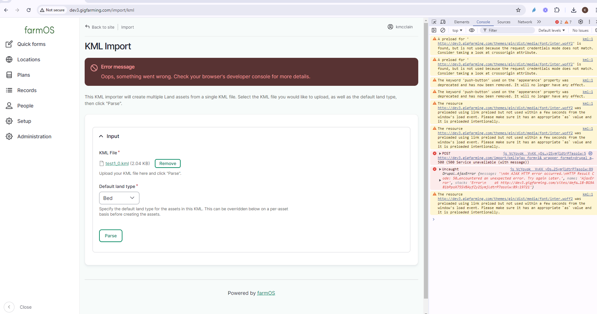
| [15:22:26] | <middyeasy[m]> | �ACTION uploaded an image: (176KiB) < https://matrix.org/_matrix/media/v3/download/matrix.org/bddQRcogVumZcZwU... >� |
| [15:24:27] | <paul121[m]> | Thanks! There should be a more detailed error message in Administration -> Reports -> Recent log messages |
| [15:24:49] | <paul121[m]> | Unfortunately the browser console won't have useful information here |
| [15:25:04] | <middyeasy[m]> | JUST FYI. I bought a Sparkfun Torch .. it in theory is supposed to have 16mm accuracy with just a WIFI survey. I am curious to find out how far OFF the manually set GPS coordinates are in real like to the ones I placed using just the FARMOS drawing tools. And if they are way off.. Is there a way to adjust the image to match the actually coordinates? |
| [15:25:29] | <middyeasy[m]> | i can recreate it easily one sec let me try. |
| [15:27:08] | <middyeasy[m]> | Type php... (full message at <https://matrix.org/_matrix/media/v3/download/matrix.org/GPrlYBBWLTiGXZIg...) |
| [15:27:56] | <middyeasy[m]> | Here is the KML file i am trying to import |
| [15:27:56] | <middyeasy[m]> | <?xml version="1.0" encoding="UTF-8"?>... (full message at <https://matrix.org/_matrix/media/v3/download/matrix.org/CUKlXhHnvOnCrjhI...) |
| [15:28:35] | <middyeasy[m]> | one should if so inclined be able to just put that into a notepad and name it test1.kml and see the same error in theory. |
| [15:31:23] | <middyeasy[m]> | s/like/life/ |
| [15:32:33] | <middyeasy[m]> | * if one should be so inclined, one could just put that into a notepad and name it test1.kml and see the same error in theory. |
| [15:36:07] | <mstenta[m]> | > Message Exception: Serialization of 'SimpleXMLElement' is not allowed in serialize() |
| [15:36:07] | <mstenta[m]> | I've seen this error pop up from time to time in Farmier server logs - but never had a chance to dig into it. Maybe we can get to the bottom of it. |
| [15:36:55] | <mstenta[m]> | middyeasy: Would you mind opening a bug report in github.com/farmOS/farmOS/issues and posting this info and screenshot? Then we at least have a tracking issue to work from |
| [15:37:27] | <mstenta[m]> | > Is there a way to adjust the image to match the actually coordinates? |
| [15:37:27] | <mstenta[m]> | Best bet is probably to make your own image layers and use that in the map instead of the default MapBox layer |
| [15:37:57] | <paul121[m]> | Yeah. Seems like a bug in upstream XML serialization or maybe this is just invalid XML? Not quite sure. |
| [15:38:02] | <mstenta[m]> | I've heard MapBox/Google layers can be off by quite a bit, depending on where on the earth it is. Sometimes you can find more regional maps that are more accurate. |
| [15:39:17] | * farmBOT has joined #farmos |
| [15:39:40] | <middyeasy[m]> | Is there a tutorial on how make your own image layer available? |
| [15:39:46] | <middyeasy[m]> | Yes ic an post on there for sure. |
| [15:45:13] | <mstenta[m]> | farmOS doesn't host map imagery itself, but if you have imagery available via a standard GeoServer (or a third-party service), it's relatively easy to add it to farmOS |
| [15:45:39] | <mstenta[m]> | This module allows you to add custom layers of various types via URL: https://www.drupal.org/project/farm_map_custom_layers |
| [15:47:07] | <middyeasy[m]> | Ok thank you I will look into that now! |
| [15:48:01] | <middyeasy[m]> | OK new bug report given. |
| [15:51:30] | <mstenta[m]> | Thanks! |
| [15:52:08] | <mstenta[m]> | Based on your screenshot, this is actually the "bulk KML importer", not the individual Land asset importer... so it's actually slightly different code involved |
| [15:52:58] | <middyeasy[m]> | oh how do i do the other one? |
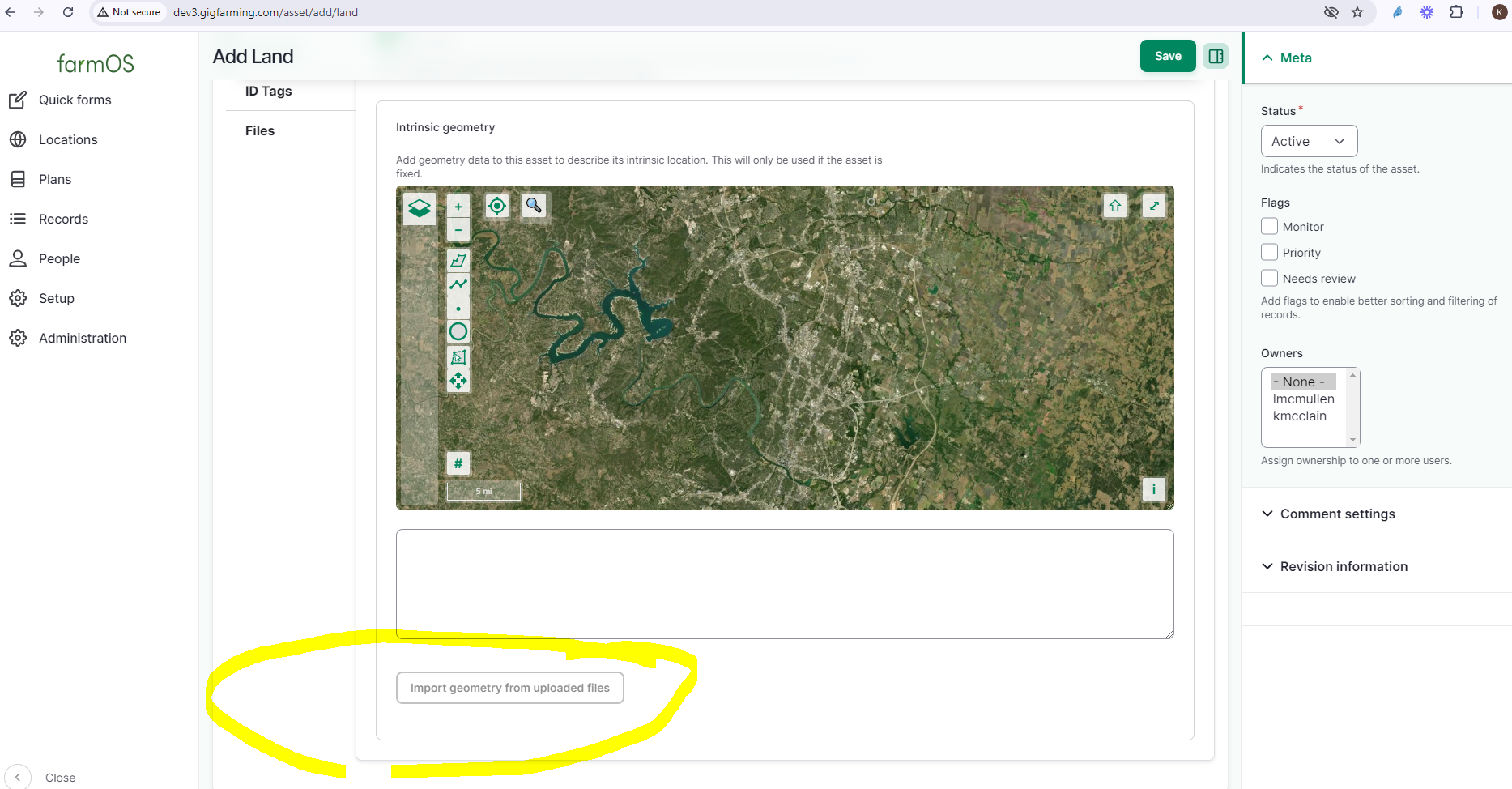
| [15:53:48] | <mstenta[m]> | Add a new land asset, upload the file to the asset, and then go to the Location tab and there's a button to import geometry from the uploaded file(s) |
| [15:53:57] | <mstenta[m]> | I would be curious if that works, but the bulk import doesn't |
| [15:54:51] | <mstenta[m]> | Here is the code we have for decoding KML in the bulk uploaded (notably NOT geophp) |
| [15:54:52] | <mstenta[m]> | https://github.com/farmOS/farmOS/blob/3a73ccf6360ba309ee657e2d645d29c239... |
| [15:55:01] | <mstenta[m]> | I bet the bug is in there somewhere... |
| [15:55:10] | <middyeasy[m]> | �ACTION uploaded an image: (1120KiB) < https://matrix.org/_matrix/media/v3/download/matrix.org/pNpGcRzqxlEPclwL... >� |
| [15:55:13] | <middyeasy[m]> | My button appears to be greyed out |
| [15:55:13] | <mstenta[m]> | It's a rather custom implementation 😅 |
| [15:56:14] | <mstenta[m]> | Hmm that's weird |
| [15:56:22] | <mstenta[m]> | Maybe try saving the asset first, and then edit again? |
| [15:56:43] | <middyeasy[m]> | Maybe you can try with my original code file put into a notepad and see if works? |
| [15:56:48] | <middyeasy[m]> | ok let me try that |
| [15:57:14] | <mstenta[m]> | Sorry I have to run right now... but please put any clues you find in your github issue! |
| [15:57:17] | <mstenta[m]> | I'll try to check back in later |
| [15:57:29] | <middyeasy[m]> | OK thank you nope still greyed out |
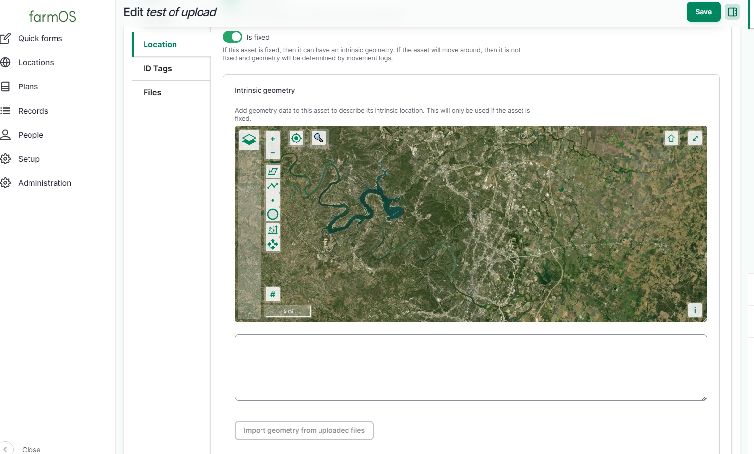
| [15:57:36] | <middyeasy[m]> | �ACTION uploaded an image: (1078KiB) < https://matrix.org/_matrix/media/v3/download/matrix.org/svAvZFNFTrXMLGWz... >� |
| [15:58:14] | <mstenta[m]> | Wonder if it's a hosting issue... you could try creating a demo farmOS instance via https://farmos-demo.rootedsolutions.io/ to see if it works differently |
| [15:58:22] | <mstenta[m]> | Although I'm not sure if demos allow file uploads... |
| [15:58:42] | <middyeasy[m]> | OK thanks Ill play around with it for a whil.e |
| [15:59:34] | <mstenta[m]> | Just checked... looks like that button is disabled if there are no files uploaded to the file field: |
| [15:59:34] | <mstenta[m]> | https://github.com/farmOS/farmOS/blob/3a73ccf6360ba309ee657e2d645d29c239... |
| [16:00:06] | <mstenta[m]> | Make sure you upload a file with a �.kml� extension to the "Files" field on the asset first |
| [16:15:46] | <middyeasy[m]> | Dudes that worked!!!! |
| [16:16:04] | <middyeasy[m]> | When adding to file first. it ungreyed and uploaded! |
| [16:17:12] | <mstenta[m]> | Oh good! |
| [16:17:56] | <mstenta[m]> | Thats probably a better option for you anyway. The other one is mainly for creating a bunch of land assets in bulk (eg: for initial farm setup) |
| [16:18:14] | <mstenta[m]> | But KML filea can be uploaded to individual asset and logs of any type |
| [16:19:16] | <middyeasy[m]> | Sweet OK well now you can say you all have a known working Survey Android App called SW MAPS! thanks for the help! |