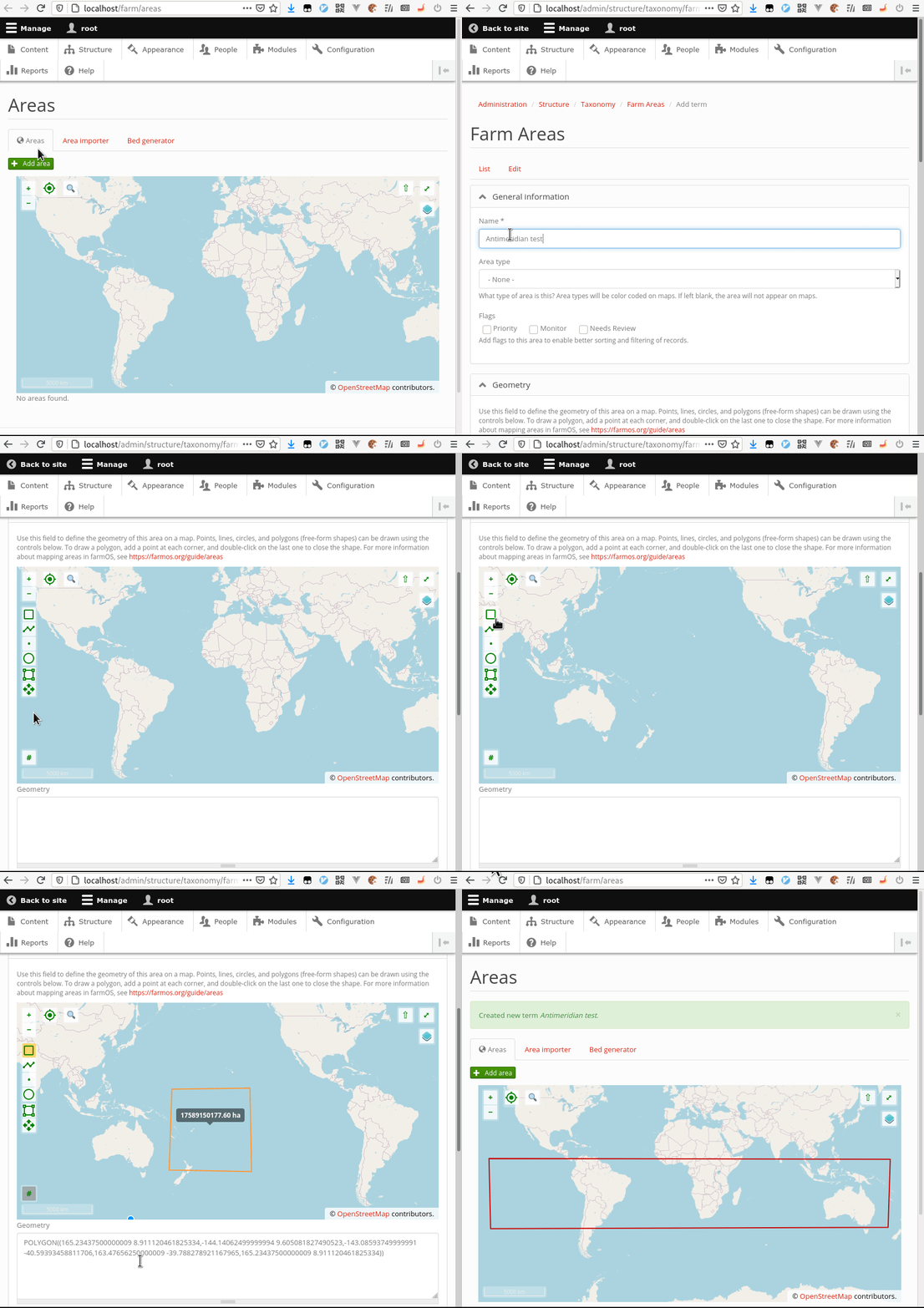
| [22:04:45] | <symbioquine[m]> | �ACTION uploaded an image: 2020_12_13_crossing_antimeridian_test.gif (2883KiB) < https://matrix.org/_matrix/media/r0/download/matrix.org/nlHZOiEQEDFEjGOH... >� |
| [22:06:04] | <symbioquine[m]> | ^ Maybe not the most critical bug, but definitely entertaining... :) |
| [22:09:30] | <mstenta[m]> | symbioquine: lol this is actually expected behavior ;-) |
| [22:09:45] | <symbioquine[m]> | oh? |
| [22:10:59] | <mstenta[m]> | ... |
| [22:11:02] | <mstenta[m]> | https://github.com/farmOS/farmOS-map/blob/master/src/projection/replaceT... |
| [22:11:11] | <mstenta[m]> | https://github.com/openlayers/openlayers/issues/3899 |
| [22:11:27] | <mstenta[m]> | i use "expected" loosely here :-P |
| [22:11:45] | <symbioquine[m]> | hmmm |
| [22:12:44] | <mstenta[m]> | iirc, i basically decided to "quick fix" another issue... but my fix creates this new issue... but i justified that that this would not be an issue for us because there are probably few farms who cross the meridian |
| [22:13:03] | <mstenta[m]> | :-P |
| [22:13:12] | <symbioquine[m]> | Yeah, that makes sense |
| [22:13:59] | <symbioquine[m]> | I was trying to test the boundary conditions of bounding box filtering in WFS, but it's a bit tricky when you can't actually create features that satisfy some of the boundary conditions :) |
| [22:14:00] | <mstenta[m]> | The original issue had to do with bug reports I was getting from folks who scrolled to the left/right on a map before starting to draw... and ended up with invalid coordinates (outside -180 +180) |
| [22:14:42] | <mstenta[m]> | happened with some farms in new zealand in particular... which was interesting :-) |
| [22:14:48] | <mstenta[m]> | (iirc) |
| [22:15:19] | <mstenta[m]> | https://github.com/farmOS/farmOS-map/issues/49 |
| [22:15:40] | <symbioquine[m]> | Interestingly QGIS sends non-compliant `EPSG:4326` bounding box coordinates when the viewing window intersects the antimeridian. |
| [22:16:06] | <mstenta[m]> | ah really - does that pose a problem? |
| [22:17:05] | <symbioquine[m]> | Not really, I was planning to do a sort of negative aware modulus to handle those coordinates... |
| [22:18:09] | <symbioquine[m]> | The main tricky thing is that it doesn't seem possible to do an `OR` SQL query via the `EntityFieldQuery` interface so I have to take the union of 2 - 4 queries. |
| [22:18:35] | <mstenta[m]> | ah |
| [22:22:50] | <symbioquine[m]> | This is interesting: https://www.linz.govt.nz/data/geospatial-data-types-general-guidance-doc... |
| [22:24:46] | <mstenta[m]> | oh wow yea interesting |
| [22:25:03] | <mstenta[m]> | > New Zealand is almost unique in the world where we have to account for the anti-meridian line, which many Geographic Information Systems (GIS) struggle with, so some guidance is also included for handling this. |
| [22:25:37] | <mstenta[m]> | first time i've heard the name "anti-meridian" :-) |
| [22:26:02] | <symbioquine[m]> | The way I read the [Wikipedia page on WKT/WKB](https://en.wikipedia.org/wiki/Well-known_text_representation_of_geometry) I was assuming the order of the coordinates could be used to communicate which is the "top left"-most point, but based on that NZ page perhaps that's not correct. |
| [22:27:19] | <mstenta[m]> | hoo boy i learned a lot when i was digging into how to calculate acreage base on GPS point geometry |
| [22:28:07] | <mstenta[m]> | who would have thought irregular spheroid geometry would be so complicated! :-P |
| [22:28:20] | <symbioquine[m]> | Yeah, that "area on a spheroid" math turns my head inside out :) |
| [22:28:41] | <mstenta[m]> | and that's not even counting elevation |
| [22:28:59] | <mstenta[m]> | if you're on a steep slope, the area can be skewed |
| [22:29:15] | <symbioquine[m]> | yeah |
| [22:30:40] | <symbioquine[m]> | You don't even have to be on a steep slope. A high irregular plateau can do the same thing since the effective radius of the earth is larger there. |
| [22:30:54] | <symbioquine[m]> | The steep slope case is of course more common. |
| [22:31:00] | <mstenta[m]> | oy |
| [22:35:11] | <symbioquine[m]> | https://core.ac.uk/download/pdf/11922683.pdf |
| [22:48:45] | <symbioquine[m]> | Tiny bit of a stretch from scientific models to data models, but the idea comes through pretty much the same - even in a pretty specific domain such as coordinate systems, no single model will (or even should) meet all use-cases. |
| [22:49:50] | <symbioquine[m]> | Even if there were some over-arching "model to rule them all" the cost/complexity probably couldn't be justified. |
| [23:01:05] | <paul121[m]> | On the topic of approximate calculations, I thought this was interesting: https://www.quantamagazine.org/mathematician-solves-centuries-old-grazin... |
| [23:01:21] | <paul121[m]> | > Mathematicians have long pondered the reach of a grazing goat tied to a fence, only finding approximate answers until now. |
| [23:02:51] | <paul121[m]> | In case we ever need to build those features into the map :D |
| [03:16:02] | * bonushenricus[m] has quit (Ping timeout: 260 seconds) |
| [03:16:03] | * munjoma[m] has quit (Ping timeout: 260 seconds) |
| [03:16:44] | * bonushenricus[m] has joined #farmos |
| [03:16:51] | * munjoma[m] has joined #farmos |
| [15:04:27] | * svenn has quit (Ping timeout: 272 seconds) |
| [15:05:39] | * svenn has joined #farmos |